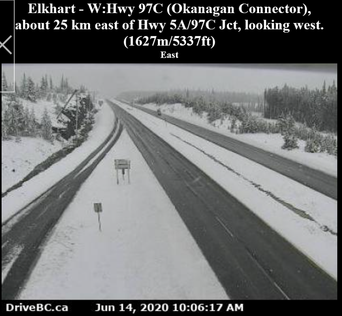
Sunday, June 14, 2020: June-uary continues! Low freezing levels mean travellers on the Okanagan Connector will experience a winter wonderland between Elkhart and Brenda Mine this morning and early this afternoon.https://weather.gc.ca/warnings/report_e.html?bc30 …#DriveBC #BCstorm
British Columbia Breaks Cold And Snow Records

Record cold and late-spring snow helped drive-home the Grand Solar Minimum message across the BC Interior over the weekend.
According to KelownaNow Meteorologist Wesla English, the Interior –one of the three main regions of the Canadian province of British Columbia– broke a slew of cold records on Saturday.
Kelowna, Kamloops, Clearwater, Penticton, Salmon Arm, and Vernon were among the areas to set new all-time record low-max temperatures for June 13.
“A cool upper low over Southern BC produced chilly temperatures on Saturday, breaking record low daytime highs in several areas,” wrote English.
Below is a breakdown of the records (data courtesy of Environment and Climate Change Canada, and originally reported by kelownanow.com):
- Kelowna set a new daily record min-high of 12.8C on Saturday, a reading comfortably topping the previous record of 13.3C set in 1981.
- Kamloops saw its all-time record low smashed, from 1923’s 15C to this weekend’s 13.4C.
- But it was Salmon Arm that actually saw the biggest change — Saturday’s low-max of 12.4C crushed the old record of 14.4C from 1971.
- Clearwater’s 12.8C busted the 13.3C from 1966.
- While the 13.9C set at Penticton pipped the previous record — 1981’s 14C.
In addition to the cold, this weekend delivered rare late-spring snow to BC, adding to Ontario’s record June snowfall last weekend that brought power outages to parts of the province.
Wet snow accumulated near the summit of the Okanagan Connector between Merritt and Kelowna on Sunday, causing Environment and Climate Change Canada to issue a special weather statement for Nicola and Okanagan Valley.
“June-uary continues!” reads a tweet issued by @ECCCWeatherBC:
All this cold and snow is negatively impacting Canadian farmers, just as it did last year when planting was the most-delayed on record. A recent report from agricensus.com warns that “cold weather is slowing emerging Canada crops”.
The COLD TIMES are returning in line with historically low solar activity, cloud-nucleating Cosmic Rays, and a meridional jetstream flow.
Even NASA agrees, in part at least, with their forecast for this upcoming solar cycle (25) seeing it as “the weakest of the past 200 years,” with the agency correlating previous solar shutdowns to prolonged periods of global cooling here.
Read more at ElectroVerse
PRINCIPIA SCIENTIFIC INTERNATIONAL, legally registered in the UK as a company  incorporated for charitable purposes. Head Office: 27 Old Gloucester Street, London WC1N 3AX.
Please DONATE TODAY To Help Our Non-Profit Mission To Defend The Scientific Method.
Trackback from your site.


Andy Rowlands
| #
It will be interesting to see if this continues in the future whether this is indicating we have reached, or are reaching, the end out our current interglacial period.
Reply
chris
| #
Billions have been wasted on building solar farms when we should have been using the money for greenhouses.
Reply